
Pioneer Petrochemical Activities
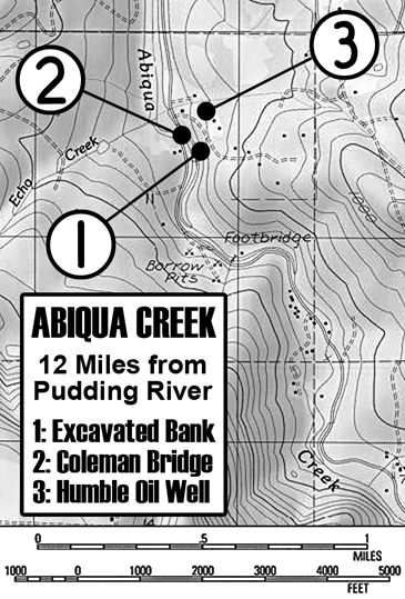
U.S.G.S. topographic map of the “El Romar” neighborhood of the upper Abiqua. Measured as twelve miles from the confluence of the Abiqua and Pudding Rivers. Locations of the following three images indicated in the key.
In the Summer of 1972 when our family moved to Silverton, my parents purchased a bit over seven acres of land along the Abiqua Creek. As the largest lot in the El Romar sub-development—adjacent to what is now known as The Concrete Bridge—it was the only one to include creek frontage. My first couple of years living in the Silverton Country included a large portion along the Abiqua Creek, with our land as a focus.
Summer spent along the creek in one of the finer old swimming holes, turned this stretch of water into somewhat of a counter-cultural recreational area. The local Hippies of the early 1970s flocked to these often “clothing optional” swimming holes. As a part of that demographic, it imparted to me a bit of an old-fashioned vibe that this Abiqua culture radiated. It also rubbed my nose in the local geology with a natural rock bed running with the water along the Abiqua. As a native Oregonian, I grew up along similar water-ways, and at first glance, it looked much the same. Then I found a chunk of coal.
I had always assumed that our state was pretty much an igneous one: Volcanic stuff from sandy ash to hard basalt. Yet here was a chunk of burnable coal. To this day, it is easy to find chunks of coal up and down certain areas along the creek. Areas that just happened to be on the property my parents purchased in 1972.
Craig Clark from The Home Seekers real estate firm that sold us the Abiqua property mentioned, to my parents that years before, there was an exploratory oil well drilled there, and the resulting dry hole was capped. After I had found the coal, the oil well started to make sense. I didn’t think further about the topic until several years ago, when I read a collection of Oregon pioneer dispatches, sent “back home” to a settler’s hometown newspaper The Illinois Journal, about various aspects of 1850s Oregon pioneer life.
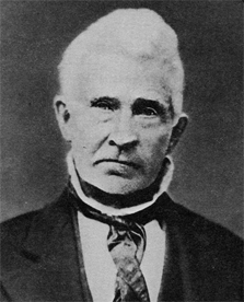
David Newsome (1805-1882)
The book, David Newsom: The Western Observer, was a collection of these short dispatches written by Mr. Newsom, (left). He and his family had a land claim near where the Abiqua joins the Pudding River. He built a mill, grew crops, raised a family and wrote about his life, warts and all. “Nusom Road” which runs through the old claim is named for him, despite the misspelling. One passage in particular dated July 4, 1852 grabbed my attention:
“An immense coal mine was found two weeks ago, 12 miles from our mill, up the stream (Abiqua) … This coal has been tried and proved of superior quality. It is called Diamond Coal.”
He also wrote a separate dispatch to the Morning Oregonian, which was published July 17, 1852:
“Mr. Editor—I would inform your readers that a valuable discovery has recently been made by Messrs. Morrison and Markham of a most extensive bed of diamond coal on the bluffs of Abiqua creek, 12 miles from its mouth, in Marion county…”
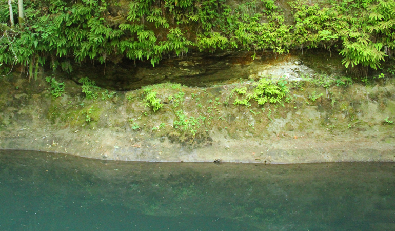
Figure 1: A large excavated area dug out from the ancient pyroclastic mud flow. It is a little over a four feet above the summer water level, about 16 inches high and deep, running along the bank for twelve feet. This appears to be the most likely location of Newsome’s “coal mine.”
Using the National Geographic Topo application on my computer, it was an easy task to quickly run a twelve mile route starting from the Pudding River up the Abiqua. The end of the line was at El Romar. Most likely the “immense coal mine” was the large excavated space on the North side of the bank, dug into the ancient pyroclastic sandstone cliff along a discontinuity between flows. I had noticed this years before, and assumed it to be some natural depression. However, the fact that it was quite a bit above the current winter water line, seemed counter intuitive to a natural explanation.
Still, pure conjecture. But there is the coal. Several years before I read Newsom’s account, I ran into Oregon Geologist William Orr at a Rock & Gem Show in Portland. He lives in Scotts Mills, so I asked him about the Abiqua Coal. He said that there was a very thin seam—less than a foot thick—of relatively “young” coal, formed during the late Eocene and early Oligocene epochs—around 34 million years ago—from plant material covered by ash flows. It was high in sulfur, and the pioneers burned through most of it in a decade or so.
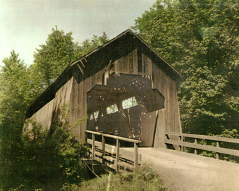
Figure 2: Coleman Covered Bridge over the Abiqua Creek. The wooden construction was built in 1925 and costs totaled $2,600. This Howe Truss was 16 feet wide and 70 feet long and had a 6-ton-load capacity for traffic. The Coleman Bridge was replaced prior to 1960.
The El Romar neighborhood has another possible place-name clue. Prior to the current Concrete Bridge, this crossing was spanned by what would be Marion County’s second-to-last covered bridge (left). Like its twin Gallon House Bridge downstream, it had a name: The Coleman Bridge. Located literally several hundred feet from the cliff-side pit. Most local place names are initially verbal, then only becoming “official” once written down. Was this bridge named because it was next to the Abiqua “Coal Man?” Maybe “Messrs. Morrison or Markham” that David Newsom mentioned? Short-lived enterprises can make long-lasting impacts on place names, even if the original context and spelling is lost.
Then there is the Abiqua oil well. I happened upon an old photograph on eBay labeled simply “Oil Derrick near Silverton, OR.” No other location was given except for “East of Silverton.” It was reasonably priced, so I purchased it. Once scanned, I noted that the background hill profile look familiar, so I once again used the Topo program and this time created a terrain profile of the hills South of El Romar. It matched the photo, which is the same oil derrick Mr. Clark told my parents about. The caption attached to the back read:
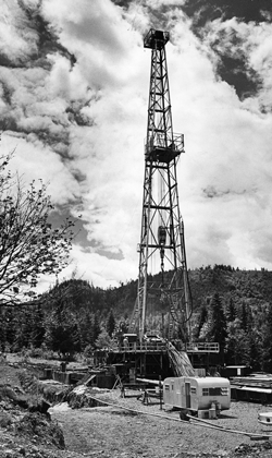
Largest oil drilling rig ever brought into Oregon (right), has begun work east of Silverton. The Humble Oil & Gas Co., contract-operated rig is capable of drilling down 20,000 feet, costs $900,000. It is 136 feet high and is driven by four 400-hp diesel engines. Humble expects to drill elsewhere in Willamette Valley, even if Silverton effort fails. Photo by David Falconer, Staff Photographer, The Oregonian. June 27, 1962
I posted the photo on the SCHS Facebook page and several old-timers recalled visiting the site when it was briefly in operation, and they confirmed the location. Thankfully, it was indeed a dry hole. To this day however, we still find coal along the creek, and sometimes observe a rainbow sheen in the mud near our hillside spring.
Reference: David Newsome (1805-1882), photo from the frontispiece of “David Newsome: The Western Observer.” Oregon Historical Society, 1972.
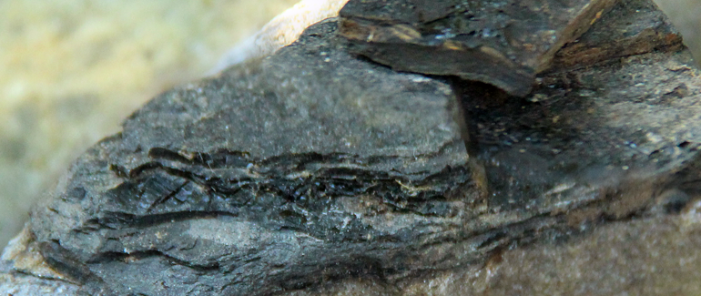
One of many pieces of coal still commonly found along the Abiqua Creek, several hundred yards upstream of the “coal mine.”